
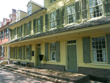
Indian King Tavern Museum
233 Kings Highway
Map / Directions to the Indian King Tavern
Map / Directions to all Haddonfield Revolutionary War Sites
For more information about the Indian King Tavern,
including hours and tour information,
see the
Friends of The Indian King Tavern website:
http://www.indiankingfriends.org
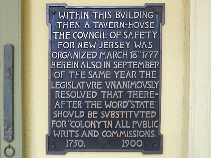
The Indian King Tavern was an important spot politically during the Revolution. The New Jersey Legislature met for three sessions between January and September 1777 on the second floor of the building in the "Great Room." Among the wartime legislation they passed were two acts of particular importance in New Jersey history:
The legislature adopted the Great Seal of New Jersey here in May of 1777.
On September 20, 1777, the legislature voted unanimously to substitute the word "State" for "Colony" in all public writs and commissions. This was significant because before the United States declared independence, New Jersey was a British colony. After declaring Independence, New Jersey, along with the other twelve original colonies, became states in the new nation.
In 1903, the Indian King Tavern became the first historic building purchased by the State of New Jersey to become a museum. [1]

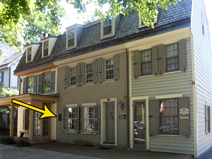
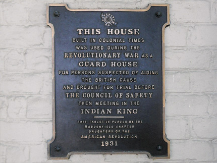
Guard House
256/ 258 Kings Highway
Across from the Indian King Tavern
This building now is used as an office building
Map / Directions to the 256 / 258 Kings Highway East
Map / Directions to all Haddonfield Revolutionary War Sites
This building, which was built before the Revolutionary War, stands across the street from the Indian King Tavern. It is now used as office space. It is marked by a plaque which explains that "during the Revolutionary War as a guard house for persons suspected of aiding the British cause and brought for trial before the Council of Safety, then meeting in the Indian King." [2]

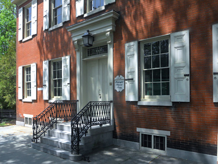
Greenfield Hall
Headquarters of the Historical Society of Haddonfield
343 King's Highway East
Map / Directions to Greenfield Hall
Map / Directions to all Haddonfield Revolutionary War Sites
Historical Society of Haddonfield website
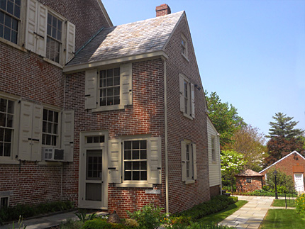
While most of Greenfield Hall was built in 1841, decades after the Revolutionary War, the two small rooms on the right of the house date to 1747. [3] It is now used as the headquarters of the Historical Society of Haddonfield.
The second picture is a close-up of the 1747 section of the building.
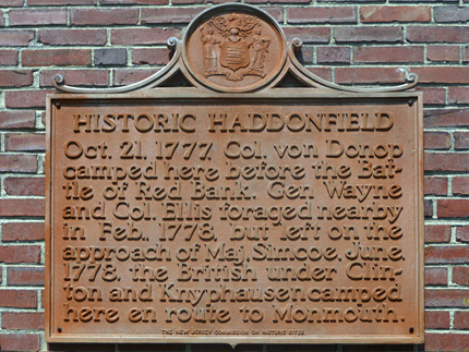
A small building behind Greenfield Hall has a historic sign which describes three Revolutionary War era events which occurred in Haddonfield during and after the British occupation of Philadelphia from September 26, 1777 until June 18, 1778: [4]
In October 1777, Hessian troops under Colonel von Donop encamped in Haddonfield before and after their defeat at the Battle of Red Bank. (See the Hessian Encampment Marker entry below for more information.)
In February, the British forces occupying Philadelphia were in need of food for their troops and for their horses. They planned a large foraging expedition into this part of New Jersey to collect cattle and hay. General Washington, then with his army at Valley Forge, Pennsylvania, received word of this plan, and he sent General "Mad Anthony" Wayne to this area to collect and take away cattle and destroy hay before the British got there.
On February 25, General Wayne was in Haddonfield, from where he wrote to General Washington that he had collected 150 head of cattle, which he had sent on, and had burned quantities of hay to keep it from the British.
General William Howe, in command of the British at Philadelphia, got word of Wayne's activities, and he ordered thousands of troops across the Delaware River into New Jersey to cut Wayne off. About 2000 British soldiers under Colonel Sterling and Major John Simcoe marched to Haddonfield. Wayne received advance warning of this, and because he was greatly outnumbered (his own forces totaled about 500, including 300 militia), he evacuated Haddonfield to Mount Holly before Simcoe's arrival.
Wayne sent a request for assistance to General Pulaski, who commanded a group of cavalry. Pulaski met up with Wayne in Mount Holly with about fifty cavalry to reinforce Wayne's strength, and they headed towards Haddonfield. Upon hearing that Wayne would be returning to Haddonfield with Pulaski's cavalry, Simcoe's troops evacuated the town and retreated to Cooper's Ferry, where they skirmished with Wayne and Pulaski's men before crossing the Delaware River back to Philadelphia on March 2.
Wayne and Pulaski's forces had been largely successful in preventing the British from capturing food. They carried only about fifty-six head of cattle with them back to Philadelphia. [5]
British and Hessian forces occupied Philadelphia from September 26, 1777 until June 18, 1778. When these troops left Philadelphia to head towards the main British stronghold in New York City, they crossed the Delaware River into Cooper's Ferry (now Camden) and began their march across New Jersey to New York. During this march, British troops under General Henry Clinton and Hessian troops under General Wilhelm von Knyphausen encamped in Haddonfield. From Haddonfield they marched on the Old Salem Road and continued their journey northeast across the state. Washington's army, who had spent the previous six months at Valley Forge, followed after the British. The two armies met and fought at the Battle of Monmouth on June 28, 1778. [6]

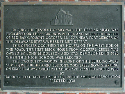
Hessian Encampment Marker
Haddonfield Memorial High School
King's Highway East
Map / Directions to the Hessian Encampment Marker
Map / Directions to all Haddonfield Revolutionary War Sites
During the Revolutionary War, British forces occupied Philadelphia from September 26, 1777 until June 18, 1778. It was during this time that the British sent Hessian troops under Colonel Carl von Donop from Philadelphia to attack Fort Mercer, an American Fort on the Delaware River in what is now National Park. (Hessians were German mercenary soldiers hired by the British to fight in the Revolutionary War.)
The Hessians crossed the Delaware River from Philadelphia into New Jersey on October 21, 1777, landing in Cooper's Ferry (now Camden). They marched to Haddonfield, where they camped for the night. Officers took up quarters in houses on the west side of Kings Highway.
The following day, the Hessians marched to and attacked Fort Mercer, in what became known as the Battle of Red Bank. They were defeated, and made their retreat to Haddonfield, where they again camped for the night. The following morning they marched back to Cooper's Ferry, from where they crossed the Delaware River back into Philadelphia. [7]
This plaque, which commemorates the location of Hessian encampments before and after the Battle of Red Bank, is located inside the breezeway in front of Haddonfield High School. [8]

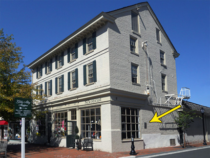
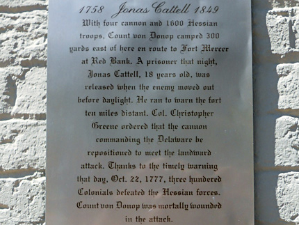
Jonas Cattell Plaque
Corner of Kings Highway and Mechanic St.
Map / Directions to the Jonas Cattell Plaque
Map / Directions to all Haddonfield Revolutionary War Sites
This plaque tells the story of Jonas Cattell at the Battle of Red Bank, "With four cannon and 1600 Hessian troops, Count von Donop camped 300 yards east of here en route to Fort Mercer at Red Bank. A prisoner that night, Jonas Cattell, 18 years old, was released when the enemy moved out before daylight. He ran to warn the fort ten miles distant. Col. Christopher Greene ordered that the cannon commanding the Delaware [River] be repositioned to meet the landward attack. Thanks to the timely warning that day, Oct. 22, 1777, three hundred Colonials defeated the Hessian forces. Count von Donop was mortally wounded in the attack." [9]
Joseph Cattell is buried in the Cattell Cemetery in Deptford NJ.

1. ^ Information and dates about the Indian King Tavern drawn from the History page of the Friends of the Indian King Tavern website, and from the plaque on the front of the building which was erected by the Daughters of the American Revolution in 1900
• On September 20, 1777, the New Jersey Legislature meeting at the Indian King Tavern passed "An ACT to ascertain the punishment for high treason, and to establish the word State instead of Colony in commissions, writs and other process; and for other purposes therein mentioned."
For the full text of the act, see:
Laws of the State of New Jersey New Jersey (New Brunswick: Abraham Blauvelt, 1800) page 38-39
Available to be read at Google Books here2. ^ Tablet erected by the Haddonfield Chapter, Daughters of the American Revolution, 1931
3. ^ History of Greenfield Hall page of the Historic Society of Haddonfield website
4. ^ Sign erected by The New Jersey Commission on Historic Sites
5. ^ • “To George Washington from Brigadier General Anthony Wayne, 25 February 1778,” Founders Online, National Archives (http://founders.archives.gov/documents/Washington/03-13-02-0566 [last update: 2015-03-20]). Source: The Papers of George Washington, Revolutionary War Series, vol. 13, 26 December 1777 – 28 February 1778, ed. Edward G. Lengel. Charlottesville: University of Virginia Press, 2003, pp. 668–671.
• “To George Washington from Brigadier General Anthony Wayne, 26 February 1778,” Founders Online, National Archives (http://founders.archives.gov/documents/Washington/03-13-02-0575 [last update: 2015-03-20]). Source: The Papers of George Washington, Revolutionary War Series, vol. 13, 26 December 1777 – 28 February 1778, ed. Edward G. Lengel. Charlottesville: University of Virginia Press, 2003, pp. 677–678.
• “From George Washington to Brigadier General Anthony Wayne, 28 February 1778,” Founders Online, National Archives (http://founders.archives.gov/documents/Washington/03-13-02-0601 [last update: 2015-03-20]). Source: The Papers of George Washington, Revolutionary War Series, vol. 13, 26 December 1777 – 28 February 1778, ed. Edward G. Lengel. Charlottesville: University of Virginia Press, 2003, pp. 700–701.
• “From George Washington to Brigadier General Anthony Wayne, 2 March 1778,” Founders Online, National Archives (http://founders.archives.gov/documents/Washington/03-14-02-0027 [last update: 2015-03-20]). Source: The Papers of George Washington, Revolutionary War Series, vol. 14, 1 March 1778 – 30 April 1778, ed. David R. Hoth. Charlottesville: University of Virginia Press, 2004, p. 42.
• “To George Washington from Brigadier General Anthony Wayne, 5 March 1778,” Founders Online, National Archives (http://founders.archives.gov/documents/Washington/03-14-02-0056 [last update: 2015-03-20]). Source: The Papers of George Washington, Revolutionary War Series, vol. 14, 1 March 1778 – 30 April 1778, ed. David R. Hoth. Charlottesville: University of Virginia Press, 2004, pp. 72–75.
• New Jersey Gazette No. 14, Mar 4, 1778, reprinted in:
Francis B. Lee, editor, Archives of the State of New Jersey, Second Series, Vol II (Documents Relating to the Revolutionary History of the State of New Jersey | Extracts from American Newspapers relating to New Jersey) (Trenton: John L. Murphy Publishing Company, 1903) page 91
Available to be read at Google Books here• "A Correspondent Desires Us to Insert The Following" New Jersey Gazette No. 15, Mar 11, 1778, reprinted in:
Francis B. Lee, editor, Archives of the State of New Jersey, Second Series, Vol II (Documents Relating to the Revolutionary History of the State of New Jersey | Extracts from American Newspapers relating to New Jersey) (Trenton: John L. Murphy Publishing Company, 1903) page 101-102
Available to be read at Google Books here• John Graves Simcoe, Simcoe's Military Journal (New York: Bartlett & Welford, 1844) pages 38-46
Available to be read at Google Books here6. ^ For more about the Battle of Monmouth, see the Manalapan page of this website.
7. ^ Samuel Stelle Smith, Fight for the Delaware, 1777 (Monmouth Beach, N.J.: Philip Freneau Press, 1970) pages 18-23.
This includes the map on page 20, which traces the route taken by the Hessian troops. The book states that the map was, "based largely on the extensive road research of Mr. Harry Marvin of Mullica Hill, N.J."
▸ The map is also reproduced on the "Fort Mercer is Attacked" sign at the Red Bank Historical Park• Information that the officers stayed in houses on the west side of the road was drawn from the plaque erected by the Haddonfield Chapter Daughters of the American Revolution in 1938
• For more information about the events mentioned in this paragraph, see the town pages linked from within the text.
8. ^ Plaque erected by the Haddonfield Chapter Daughters of the American Revolution in 1938
9. ^ Sign erected by The Francis Hopkinson Chapter, Sons of the American Revolution in 1980